羅臼岳
Mt. Rausu
Elevation: 1661m
Prefecture
Hokkaido
Distance
13.3 km
Elevation Gain
1450m
Time
8 Hours
Difficulty
4/5
Accommodation
Mountain Huts
Overview
Mt. Rausu is the highest mountain located on the Shiretoko Peninsula, which is famous for having the highest population of brown bears in Japan. The peak is renowned for its high winds and has a spectacular 360-degree view. The terrain is mostly a forest trail with 1/3 of it inside a small creek bed which can be a bit difficult on rainy days, while the top section of the hike features large boulders. Aside from bears, there is an abundance of wildlife here and it's quite common to see deer and foxes during your hike. Bear spray can be rented for ¥2000 at the mountain hut located next to the trailhead, this is highly recommended as there are frequent bear sightings on the trail.
Access
Car
The trailhead is located behind the Chinohate hotel, parking here is free but there's not much space, it often fills up by 6am on the weekend during summer, but there is some overflow parking along the road.
Train - Bus - Taxi - Hotel Shuttle
Access without a car is quite difficult, your options are:
1. Catch a bus to the town of Utoro, then a taxi to the trailhead - a taxi will cost about ¥7000. There is an overnight bus to Utoro from Sapporo, you can make reservations here.
2. From Shari-Shiretoko Station, catch an 80 min bus to the Iwaobetsu bus stop, then walk 40 mins to the trailhead. Confirm the timetable here.
3. Book a night at the Chinohate Onsen Hotel, they will pick you up from the Iwaobetsu bus stop. The price ranges from ¥10,000 to ¥20,000.
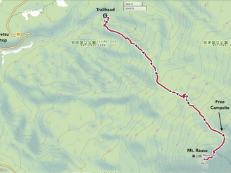
GPS map: outdooractive.com
Buy the Mt. Rausu hiking map: Amazon
Maps
Trail Description
At the trailhead you will find a notice board and a map showing the most recent bear sightings. If you choose to rent bear spray, you'll have to spend around 10 minutes filling out a form, you'll also need ID. The hike usually takes about 4-5 hours up and 3-4 hours down, prepare for a windy summit and sudden weather changes. When we hiked this, we had a forecast for a nice and sunny day with no rain, but the weather was quite extreme. It had been lightly raining all night, which continued in the morning and during our hike, filling up the creek bed that features on 1/3 of the trail. Once we broke through the tree line, we were greeted with intense winds, and completely covered in cloud, at this point we stopped to discuss turning back. Drenched and cold, we pushed on, and the wind became even more intense. Keeping a strong pace kept us warm, and the extreme wind ending up fuelling our excitement, it was crazy! The summit was like sticking your head out of a car moving 100kph, but in dense fog and 10 meters visibility. The peak is not always like this, but it's known for being windy. That afternoon everything cleared up and we watched incredible cloud formations rolling across the peak from the nearby observation deck.
After the hike you can wash yourself off at the free natural hot springs located in front of the hotel parking.
Elevation Profile

Weather and Seasons
The summer months including July, August, and September are considered the best time for hiking Mt. Rausu. Snowfall will typically occur from October to May, with autumn colours reaching their peak around the end of September.
Useful links
Accommodation
Cautions
Altitude & Weather
Bears
Gallery

Difficulty: 4/5
Hiking Distance: 13 km
Time: 8 hours
Elev. gain: 1450m
Prefecture: Hokkaido
Related Articles


